
California wildfire map update as Clay Fire ignites
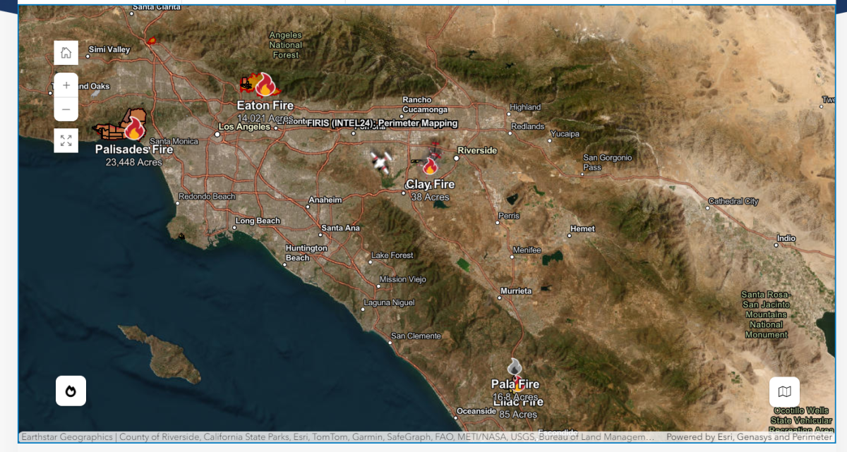
The Clay Fire in Riverside County, near Los Angeles, has ignited on Tuesday evening, growing to nearly 40 acres and prompting evacuation warnings.
Why It Matters
The Clay Fire is the latest fire to erupt as Southern California has been inundated with deadly wildfires in January.
The Palisades Fire and the Eaton Fire grew to be the largest, leading to numerous evacuation orders and destroying thousands of structures. Air quality is also a growing concern for residents as the containment of these fires continues.
California Governor Gavin Newsom and Los Angeles Mayor Karen Bass, both Democrats, have faced fierce criticism in the aftermath of the wildfires as some residents have pointed to potential water issues contributing to the situation.
What To Know
In an update by the California Department of Forestry and Fire Protection on Tuesday at 6:49 p.m. PT, the Clay Fire is burning near Pedley Road and Van Buren Boulevard, in Jurupa Valley.
The fire is 38 acres and is currently zero percent contained, CAL Fire says. The cause of the fire is also under investigation. An evacuation warning has been issued for these zones, CAL Fire says: JUR-0177, JUR-0178, JUR-0179, JUR-0181.
Below is a map of the impacted area:
Meanwhile, the Palisades Fire is currently 65 percent contained as of 6:32 p.m. PT on Tuesday. The cause of the fire remains under investigation, CAL Fire notes. The fire is over 23,000 acres in size and impacted the communities of Pacific Palisades, Malibu, Santa Monica, and Brentwood.
The Eaton Fire which impacted the communities of Pasadena and Altadena is currently 89 percent contained, as of a 6:41 p.m. PT update by CAL Fire. The fire grew to over 14,000 acres and the cause of the fire remains under investigation.
Portions of Southern California near Los Angeles remain under a red flag warning as Santa Ana winds continue to blow. The National Weather Service Los Angeles (NWS) noted on X, formerly Twitter, on Tuesday that the area has “significant fire weather conditions” amid severely dry environments and the raging winds.
Newsweek reached out to the NWS via email on Tuesday night for comment.
Below is a photo from CAL Fire of multiple wildfires in Southern California:
What People Are Saying
The Riverside County Fire Department said on X on Tuesday: “#ClayIC [UPDATE]: The fire is 38 acres. The fire continues to burn in heavy vegetation. There is now an evacuation WARNING for the following zones: RVC-177, RVC-178, RVC-179, RVC-181. South of Limonite Avenue, East of Beach Street, West of Van Buren.”
The NWS Los Angeles in a post on X on Tuesday: Significant fire weather conditions are ongoing into Thursday with an increase in winds expected (especially Thurs AM) and severely dry conditions. For wildfire preparedness guidance visit https://readyforwildfire.org/prepare-for-wildfire/.”
California Governor Gavin Newsom said in a post on X on Tuesday: “We are working proactively to protect firestorm-affected communities from potential landslides and flooding.
Firefighting crews right now are filling sandbags to be placed in impacted areas to protect communities in the event of winter storms.”
What Happens Next
The NWS says the red flag warning will expire on Thursday evening.